5 Hikes Near Cusco That Don’t Lead to Machu Picchu
Machu Picchu may be the bait that lures most visitors to the Cusco Region of Peru, but it's by no means the only Inca ruin to astound them once they arrive. The high Andean plateau surrounding the historic city of Cusco is littered with archeological marvels. Many are just a short hike away from the modern towns that they unwittingly gave birth to. Others lie far from the nearest road and require multiday journeys across steep river valleys and cloud-covered mountain passes.
Here's a look at five of the best hikes near Cusco that pair sweeping Andean vistas with beguiling Inca ruins. Each offers a great alternative to the heavily touristed trails leading to Machu Picchu. Collectively, they make for a fantastic two-week adventure through Peru's Sacred Valley and beyond — one that paints a broader picture of both the scope of the Inca Empire and the cultural inheritance preserved in the modern-day Andean experience.
Pisac

This easy two-mile hike takes you down a steep sun-baked hill through the expansive Incan fortress of Pisac. Begin with a quick stroll atop the ancient agricultural terraces up to the Qalla Q'asa section, where the strategic importance of this citadel, which looks out over three Andean valleys, becomes abundantly clear. Once you've explored the ruins above, follow the path that skirts alongside a ridge below through a rock tunnel toward the Inti Watana and P'isaqa sectors, which are open-air museums of Incan artistry with well-preserved temples, working water channels and stone walls showcasing meticulous masonry. Row upon row of precipitous steps soon lead into the artisan market of Pisac town, peppered with Technicolor textiles and exotic fruits.
RELATED: A Guide to Hiking Machu Picchu
Getting there: Take a Pisac-bound colectivo (minibus) from Cusco's Terminal Minivan Pisac & Urubamba. Once in Pisac, hire a taxi to drive you 20 minutes up a winding road to the entrance gate for the archeological site. Follow the steep path downhill back to Pisac and return by colectivo to Cusco.
Tambomachay to Cusco

The area immediately northeast of Cusco is a treasure trove of Incan wonders, and this easy 4.5-mile hike takes in the best of the bunch. Begin at Tambomachay, the "Incan spa," which is the furthest of eight archeological sites that dot the road back to Cusco. On the far side of the road from Tambomachay lies Puka Pukara, a former military control post and administrative center with killer views over the Cusco Valley. A leisurely three-mile walk toward Cusco takes you to Q'enqo, a holy site where archeologists believe sacrifices and mummifications took place. Sacsayhuaman is less than a mile away and is the final and largest ruin of the hike. This massive fortress of boulders and stone walls predates the Inca Empire and sits like a sentinel overlooking the city below. A steep path down the hill will drop you in Cusco's central plaza in about 20 minutes.
Getting there: Take a Pisac-bound colectivo from Cusco's Terminal Minivan Pisac & Urubamba. Ask the driver to let you off at Tambomachay and follow the road and its splintering trails back to Cusco.
Moray to Maras

This easy-to-moderate 7.5-mile hike across Andean farmland connects two important Incan sites: the agricultural terraces of Moray and the salt evaporation ponds near Maras. Begin at the bullseye-like terraces of Moray, which have a temperature difference of 25 degrees from top to bottom. Archeologists believe the Incas used these terraces for experiments to find out what crops grew best in which temperatures. Hike along the mule trail away from Moray for just over three miles until you reach the colonial village of Maras. From there, it's another three miles downhill until you encounter the stunning salt mines of Maras. These shallow ponds, carved into an expansive earthen bowl, have been used since pre-Inca times to harvest salt through the process of evaporating salty water. Continue hiking downhill to the Urubamba River, cross over the bridge, and walk two blocks to the main highway to wait for a colectivo.
Getting there: Take any colectivo from Cusco that heads to Urubamba via Chinchero and ask to be let off at the Maras/Moray turn-off. From there, you can hire a waiting driver to take you the remaining six miles to the archeological site of Moray (alternatively, just hire a taxi from Cusco to take you directly to Moray). This one-way hike ends at Av. Ferrocarril about four miles west of Urubamba. Wave down a passing colectivo and get off at Urubamba, where you can transfer for another colectivo headed to Cusco.
Cachicata

This moderate three-day, 19-mile trek is one of the most varied hikes on the list, passing canals, mountain passes, and lagoons before dropping you off at the ruins of Ollantaytambo. Begin in the small town of Socma, following the valley behind town to the archeological site of Perolniyoc, which is perched atop a ribbon-like waterfall. Stay in the high altitude campground at Rayan before hiking over a 14,764-foot mountain pass the next morning to the Mama Cona Lagoon. Continue to the northeast alongside an ancient Incan canal that still, to this day, transports water to the Cachicata quarry. After you pass the famed "Sun Gate" ruins, you'll descend to the town of Cachicata to camp for the evening. A short hike on Day Three takes you across the Urubamba River and into the impeccably preserved Incan village of Ollantaytambo, the Sacred Valley's most popular base for trips to Machu Picchu. Spend the afternoon exploring the Incan ruins that climb up the valley walls on either side of town.
Getting there: Take a colectivo from Cusco's Terminal Minivan Izcuchaca to the town of Izcuchaca where you can transfer to another colectivo bound for Socma. On the way back, colectivos will leave from Ollantaytambo town square for Cusco (via Urubamba) throughout the day. Buses go direct to Cusco from the Ollantaytambo Station, where trains arrive from Machu Picchu.
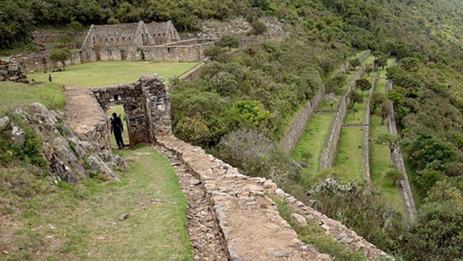
Choquequirao

This difficult four-day, 40-mile round-trip hike leads to Machu Picchu's "sister city," which archeologists believe could be three times larger than its more famous neighbor (though just a third of it has been recovered from the jungle). Day One begins with a 1,500m (4,920-foot) drop down a steep canyon to the Apurimac River, where you'll set up camp for the evening at Playa Rosalina campground. Start early on Day Two for the arduous 5,900-foot uphill march to the mountaintop village of Marampata, which boasts a campground and small shop that sells supplies carted up by mules. Spend the morning of your third day exploring the expansive ruins of Choquequirao, which straddles a 9,843-foot peak and spills down the mountain in three directions. There are rarely more than a dozen hikers here at any given time and many find the private experience more awing than Machu Picchu. Return to Playa Rosalina to camp for the evening before hiking back up to Cachora on Day Four. It's best to hire a local guide for this hike unless you speak Spanish and have prior knowledge of the terrain. Cachora-based outfits like Trekking Choquequirao offer rates that are half the price of what you'd pay in Cusco and help bring money into the local community.
Getting there: Buses depart for Abancay from Cusco's Terminal Terrestre at regular intervals throughout the day. Make sure to ask the driver to be let off at "Ramal de Cachora," a three-house hamlet where taxis wait to cart hikers the remaining 30 minutes down to the village of Cachora. On the way back, grab a taxi from Cachora's central plaza to Ramal de Cachora and wave down a passing bus headed to Cusco.